![](/images/other/stat-length.png)
![Excursión Bici de carretera Valgelon-La Rochette - col de la cochette depuis la rochette - Photo](https://media.geolcdn.com/t/1900/400/b6650d40-cb31-4fbe-a28a-fc1595ab82df.jpg&format=pjpeg&maxdim=2)
col de la cochette depuis la rochette
scalpy
Usuario
![Longitud](/images/other/stat-length.png)
Longitud
32 km
![Altitud máxima](https://static1.geolcdn.com/siteimages/upload/files/1508320355ic_sort_altitude_max_24dp.png)
Altitud máxima
590 m
![Desnivel positivo](https://static1.geolcdn.com/siteimages/upload/files/1508320355ic_sort_den_pos_24dp.png)
Desnivel positivo
706 m
![Km-Effort](/images/other/stat-length.png)
Km-Effort
42 km
![Altitud mínima](https://static1.geolcdn.com/siteimages/upload/files/1508320355ic_sort_altitude_min_24dp.png)
Altitud mínima
256 m
![Desnivel negativo](https://static1.geolcdn.com/siteimages/upload/files/1508320355ic_sort_den_neg_24dp.png)
Desnivel negativo
708 m
![Boucle](https://static1.geolcdn.com/siteimages/upload/files/16400158638029165_repeat_loop_refresh_sync_direction_icon.png)
Boucle
Sí
Fecha de creación :
2022-08-07 12:27:42.951
Última modificación :
2022-08-07 14:50:53.645
![Bici de carretera](https://static1.geolcdn.com/sitytour/trail-icons/201.png)
2h22
Dificultad : Muy difícil
![Escanee este código QR para abrir la excursión en la aplicación SityTrail](https://capi.geolives.com/qq0zvz2zws4bq2lad0pu/sitytour/trails/3346134/qr.png?size=200)
Aplicación GPS de excursión GRATIS
A propósito
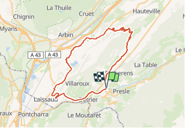
Ruta Bici de carretera de 32 km a descubrir en Auvergne-Rhône-Alpes, Saboya, Valgelon-La Rochette. Esta ruta ha sido propuesta por scalpy.
Descripción
départ de la rochette puis boucle num.47. col bien difficile mais super bucolique
Localización
País:
France
Región :
Auvergne-Rhône-Alpes
Departamento/provincia :
Saboya
Municipio :
Valgelon-La Rochette
Localidad:
La Rochette
Salida:(Dec)
Salida:(UTM)
274744 ; 5037811 (32T) N.
Comentarios
Excursiones cerca
![Excursión Senderismo Arvillard - Les Grands Moulins 2495m - Photo](https://media.geolcdn.com/t/375/260/ext.jpg?maxdim=2&url=https%3A%2F%2Fservices.sitytrail.com%2FGeolivesWS%2FDownloadMedia.ashx%3FTrailID%3D102590%26Media%3D3501_1.jpg)
![Senderismo Senderismo](https://static1.geolcdn.com/sitytour/trail-icons/101.png)
Les Grands Moulins 2495m
Senderismo
Difícil
(1)
Arvillard,
Auvergne-Rhône-Alpes,
Saboya,
France
![](/images/other/stat-length.png)
9 km | 20 km-effort
5h 0min
![](https://static1.geolcdn.com/siteimages/upload/files/16400158638029165_repeat_loop_refresh_sync_direction_icon.png)
Sí
![Excursión Bici de montaña Valgelon-La Rochette - plan perrier + montmayeur - Photo](https://media.geolcdn.com/t/375/260/ext.jpg?maxdim=2&url=https%3A%2F%2Fstatic1.geolcdn.com%2Fsiteimages%2Fupload%2Ffiles%2F1524743154velo.jpg)
![Bici de montaña Bici de montaña](https://static1.geolcdn.com/sitytour/trail-icons/202.png)
plan perrier + montmayeur
Bici de montaña
Medio
(1)
Valgelon-La Rochette,
Auvergne-Rhône-Alpes,
Saboya,
France
![](/images/other/stat-length.png)
25 km | 34 km-effort
2h 49min
![](https://static1.geolcdn.com/siteimages/upload/files/16400158638029165_repeat_loop_refresh_sync_direction_icon.png)
Sí
![Excursión Senderismo Presle - tour du chapoté - Photo](https://media.geolcdn.com/t/375/260/60fd499a-f8ff-490d-892e-e5c9e4e4a7a6.jpg&format=jpg&maxdim=2)
![Senderismo Senderismo](https://static1.geolcdn.com/sitytour/trail-icons/101.png)
tour du chapoté
Senderismo
Muy difícil
Presle,
Auvergne-Rhône-Alpes,
Saboya,
France
![](/images/other/stat-length.png)
13,2 km | 24 km-effort
3h 50min
![](https://static1.geolcdn.com/siteimages/upload/files/16400158638029165_repeat_loop_refresh_sync_direction_icon.png)
Sí
![Excursión Senderismo Presle - Le chapotet au départ de Prodin - Photo](https://media.geolcdn.com/t/375/260/4998ab41-5166-4f21-a80b-af21151571f7.jpg&format=jpg&maxdim=2)
![Senderismo Senderismo](https://static1.geolcdn.com/sitytour/trail-icons/101.png)
Le chapotet au départ de Prodin
Senderismo
Medio
Presle,
Auvergne-Rhône-Alpes,
Saboya,
France
![](/images/other/stat-length.png)
12,1 km | 23 km-effort
5h 0min
![](https://static1.geolcdn.com/siteimages/upload/files/16400158638029165_repeat_loop_refresh_sync_direction_icon.png)
Sí
![Excursión Senderismo Presle - 2023-06-15 Prodin -Col de la Perche en boucle - Photo](https://media.geolcdn.com/t/375/260/fea8337f-6305-49a4-963c-b11328735eeb.jpg&format=jpg&maxdim=2)
![Senderismo Senderismo](https://static1.geolcdn.com/sitytour/trail-icons/101.png)
2023-06-15 Prodin -Col de la Perche en boucle
Senderismo
Medio
Presle,
Auvergne-Rhône-Alpes,
Saboya,
France
![](/images/other/stat-length.png)
12 km | 22 km-effort
4h 34min
![](https://static1.geolcdn.com/siteimages/upload/files/16400158638029165_repeat_loop_refresh_sync_direction_icon.png)
Sí
![Excursión Senderismo La Trinité - les Tours de Montmayeur - Photo](https://media.geolcdn.com/t/375/260/43d702d0-e21c-40d5-9cd6-c43ff15ff6cf.jpg&format=jpg&maxdim=2)
![Senderismo Senderismo](https://static1.geolcdn.com/sitytour/trail-icons/101.png)
les Tours de Montmayeur
Senderismo
Difícil
La Trinité,
Auvergne-Rhône-Alpes,
Saboya,
France
![](/images/other/stat-length.png)
16,3 km | 24 km-effort
6h 27min
![](https://static1.geolcdn.com/siteimages/upload/files/16400158638029165_repeat_loop_refresh_sync_direction_icon.png)
No
![Excursión Senderismo La Trinité - Les Tours de Montmayeur au départ de la Trinité via col de Cochette - Photo](https://media.geolcdn.com/t/375/260/2f6517bb-96f3-4790-8320-59ad14424ecc.jpg&format=jpg&maxdim=2)
![Senderismo Senderismo](https://static1.geolcdn.com/sitytour/trail-icons/101.png)
Les Tours de Montmayeur au départ de la Trinité via col de Cochette
Senderismo
Fácil
La Trinité,
Auvergne-Rhône-Alpes,
Saboya,
France
![](/images/other/stat-length.png)
12,9 km | 20 km-effort
4h 44min
![](https://static1.geolcdn.com/siteimages/upload/files/16400158638029165_repeat_loop_refresh_sync_direction_icon.png)
Sí
![Excursión Senderismo Arvillard - Crete du Gargoton - Photo](https://media.geolcdn.com/t/375/260/c9c62c49-770b-457d-b723-13784f4fc8a6.jpg&format=jpg&maxdim=2)
![Senderismo Senderismo](https://static1.geolcdn.com/sitytour/trail-icons/101.png)
Crete du Gargoton
Senderismo
Difícil
Arvillard,
Auvergne-Rhône-Alpes,
Saboya,
France
![](/images/other/stat-length.png)
10 km | 19,8 km-effort
7h 18min
![](https://static1.geolcdn.com/siteimages/upload/files/16400158638029165_repeat_loop_refresh_sync_direction_icon.png)
Sí
![Excursión Senderismo Arvillard - val pelouse - Photo](https://media.geolcdn.com/t/375/260/ext.jpg?maxdim=2&url=https%3A%2F%2Fstatic1.geolcdn.com%2Fsiteimages%2Fupload%2Ffiles%2F1553511878bg_sport_marche.png)
![Senderismo Senderismo](https://static1.geolcdn.com/sitytour/trail-icons/101.png)
val pelouse
Senderismo
Muy fácil
(1)
Arvillard,
Auvergne-Rhône-Alpes,
Saboya,
France
![](/images/other/stat-length.png)
7,7 km | 14,3 km-effort
3h 48min
![](https://static1.geolcdn.com/siteimages/upload/files/16400158638029165_repeat_loop_refresh_sync_direction_icon.png)
No